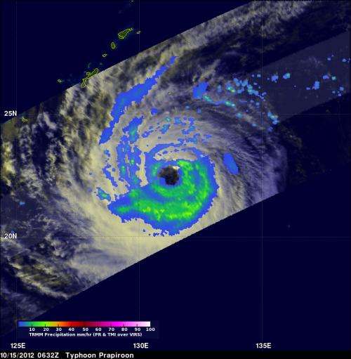
NASA satellite indicates Tropical Storm Prapiroon's rains mostly south of center

Tropical Storm Prapiroon is still meandering in the western north Pacific Ocean, and NASA's TRMM satellite noticed that dry air and wind shear are adversely affecting rainfall north of the storm's center.
NASA's Tropical Rainfall Measuring Mission (TRMM) satellite flew above Prapiroon when it was a typhoon on Oct. 15, 2012 at 0632 UTC (2:32 a.m. EDT). Prapiroon's sustained wind speeds had dropped to 70 knots (~81 mph) with a large and ragged eye being its dominant feature. TRMM's Microwave Imager (TMI) data indicated that the most intense rain bands south of Prapiroon's eye were dropping rain at a rate of about 30-40 mm/hour (~1.2 to 1.6 inches).
The erosion of the rainfall was still happening in satellite imagery on Oct. 16, and the bulk of the showers were occurring south of the center. Dry air has also been affecting the north side of the storm, and dry air absorbs the moisture that helps create the clouds and thunderstorms that make up the storm. The bands of showers and thunderstorms in the southern quadrant, however, are still strong.
On Oct. 16, 2012 at 1500 UTC, Tropical Storm Prapiroon, known as "Nina" in the Philippines, had maximum sustained winds near 60 knots (69 mph/111 kph). It was located near 22.2 North latitude and 129.3 East longitude, about 260 nautical miles (299 miles/481.5 km) south-southeast of Kadena Air Base, Okinawa, Japan. It was still moving slowly, just 5 knots (5.7 mph/9.2 kph) to the west. Prapiroon is still meandering until a mid-latitude shortwave trough (elongated area of low pressure) moving into central China can push it to the northeast.
Prapiroon is not expected to strengthen before it begins moving to the northeast on Oct. 17. The Joint Typhoon Warning Center forecasts the storm to become extra-tropical thereafter.
Provided by NASA's Goddard Space Flight Center


