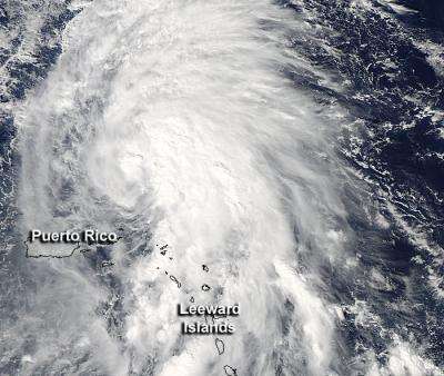
NASA eyes Tropical Storm Rafael battering the Leeward Islands

While the Leeward Islands continue to get battered by Tropical Storm Rafael, a Tropical Storm Watch is posted for Bermuda as Rafael continues to move through the eastern Atlantic Ocean. NASA's Aqua satellite passed over Rafael on Oct. 14 and noticed the bulk of showers and thunderstorms were being pushed north and east of the storm's center.
The Moderate Resolution Imaging Spectroradiometer (MODIS) instrument aboard NASA's Aqua satellite captured a visible image of Tropical Storm Rafael in the Atlantic Ocean on Oct. 14, 2012 at 1720 UTC (1:20 p.m. EDT). The image clearly showed that the bulk of Rafael's heaviest showers and thunderstorms were concentrated east of the center of circulation.
Those heavy showers are expected to bring between 1 and 3 inches of rainfall over the northern Leeward Islands with isolated totals to 12 inches. Flash flooding and mudslides are always a major concern with this kind of rainfall.
On Oct. 15 at 8 a.m. EDT, Rafael was approaching hurricane strength with maximum sustained winds near 70 mph (110 kph). It was located about 290 miles (465 km) north of San Juan, Puerto Rico, and 680 miles (1,090 miles) south of Bermuda near 22.5 North and 65.5 west. Rafael was moving to the north-northwest at 9 mph (15 kph) and is expected to turn to the north. Satellite imagery on Oct. 15 does not yet reveal an eye.
Forecasters at the National Hurricane Center expect Rafael to approach Bermuda late on Tuesday, Oct. 16.
Meanwhile, heavy surf and swells are expected the eastern facing beaches of the Bahamas, the northern Leeward Islands, and the north and east facing beaches of Puerto Rico. In a couple of days, Rafael will be moving into cooler waters and an area of higher wind shear, but is expected to intensify a little more before that time.
Rafael developed on Friday, Oct. 12 at 7:30 p.m. EDT from System 98L. When it organized into a tropical storm, it was located near 15.0 North and 63.1 West, about 125 miles (200 km) west-southwest of Domincia, causing tropical storm warnings in the U.S. Virgin Islands at that time. When Rafael developed, its maximum sustained winds were near 40 mph, and now forecasters are watching Rafael to see if the storm will become a hurricane.
Provided by NASA's Goddard Space Flight Center


