Maps used to convey relationship between rainfall and 'human vulnerability' in 8 countries
The Center for International Earth Science Information Network (CIESIN) has worked closely with CARE and the United Nations University to develop a series of maps illustrating results from case studies in eight countries for the Where the Rain Falls project. The project aims to illustrate the relationship between rainfall variability and human vulnerability in the context of a changing climate, livelihoods, and migration as a strategic response.
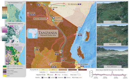
The map of northern Tanzania featured here illustrates these interrelationships. Located in Eastern Africa, the United Republic of Tanzania has an area of about 945,000 square kilometers (about the size of Texas and New Mexico combined) with a population of about 46 million people in 2012. Tanzania's long-term economic growth is dependent on its many natural resources, including wildlife, forestry, fisheries, mining, land, and water. Three-quarters of the population is employed in the agricultural sector.
The frequency and severity of droughts, floods, and storms are projected to increase globally, based on our understanding of climate change, and this is likely to affect agricultural production, food security, and gross domestic product (GDP) in the country. In addition, national efforts to address poverty and attain the Millennium Development Goals (MDGs) may be undermined by climate variability and extreme weather events. The impact that climate variability has on predominantly rain-fed agrarian economies can be seen in Tanzania, where GDP is closely tied to variations in rainfall. About half of Tanzania's GDP comes from agricultural production (including livestock), the majority of which is rain-fed and highly vulnerable to droughts and floods. Thus both farmers and herders are highly dependent on the climate for their livelihoods.
Field research for Where the Rain Falls in Tanzania was conducted in three villages (Bangalala, Ruvu Mferejini and Vudee) in the Same District of the Kilimanjaro Region. Although the three villages reflect a wide range of agricultural and climatic conditions in the upland and lowland areas of the Pangani Basin (see Google map images to the right in the map), residents share a high degree of dependence on crop and livestock production for their livelihoods. Local agriculture, in turn, is highly reliant on local rainfall, either directly or via local irrigation systems (including ndiva, micro-dams based on the concept of traditional local water reservoirs), which show a high degree of variability and unpredictability. Residents are therefore very worried about the degradation of the local environment brought on by recurrent droughts, continuing population growth, lack of enforcement of laws against logging, and other destructive practices in critical watersheds.
In the insets on the left side of the map, we can see that this region, with 600–700mm of precipitation a year, has barely enough rainfall to support agriculture in a tropical climate zone. When rainfall falls much below this level—as occurs periodically—rainfed crops will fail. In the middle inset we see where the areas with greatest land coverage of rainfed agriculture (26-100%) are located; and in the bottom inset, that maize, rice, cowpeas, sweet potatoes, and sisal are the staple crops. Further to the north, in one of the migration destination areas (Moshi), there is a high concentration of irrigated agriculture, mostly sisal production.
Across the three villages, research participants perceived a number of significant changes in rainfall patterns over recent decades. Most significant were:
- a shortening of the growing season;
- increased frequency of dry spells during the rainy season; and
- more frequent heavy storms.
Under the conditions that prevail in Same District, changes in rainfall patterns translate directly into impacts on crop and livestock production and food security. Water scarcity is the most commonly identified problem by the residents of this area, and research participants consistently identified drought as the biggest threat to their livelihoods. Given the dearth of alternative local off-farm employment opportunities, migration is a very important risk management strategy for households in these villages. Migration patterns vary across the three villages, but seasonal migrants outnumber those migrating for more than six months. Although the largest migration flows seem to be to another rural area, rural-to-urban migration is also seen, with nearly one-third of survey respondents identifying Tanzania's capital, Dar es Salaam, as the most common destination. The elderly and women with young children are most likely to be left behind, weakening their support system and increasing their labor, so they are likely to be the most vulnerable to the negative impacts of rainfall variability on household food security.
More information: Direct links to maps for all countries included in the research can be found at wheretherainfalls.org/the-study/maps/ and to an interactive map viewer, customized for each of the countries, at beta.ciesin.columbia.edu/care-mapclient.
Provided by Columbia University


