NASA satellite sees western north Pacific Tropical Cyclone strengthening

NASA satellite data has watched cloud temperatures drop in a low pressure system in the western North Pacific Ocean called System 92W, indicating that there's more uplift and power in the storm. That's a sign the storm is strengthening.
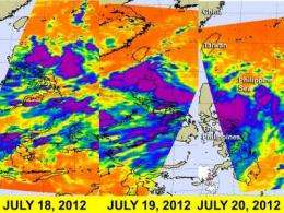
Infrared data gathered by NASA's Atmospheric Infrared Sounder (AIRS) instrument indicate cloud top temperatures as well as sea surface temperatures. NASA's Aqua satellite passed over System 92W on July 18, 19 and 20 and watched the low pressure area develop east of the Philippines, organize and move northeast of Luzon, Philippines by July 20.
On Wednesday, July 18 at 1705 UTC (1:05 p.m. EDT/U.S.), System 92W's center east of Luzon, and there were several areas of strong convection (rising air that form thunderstorms that make up a tropical cyclone). They appeared disorganized in satellite imagery at that time, however.
On Thursday, July 19, AIRS data showed a much larger and more concentrated area of strong convection and thunderstorms. AIRS data revealed strong thunderstorms with cloud top temperatures colder than 220 kelvin (-63.6 F/-53.1C) and heavy rainfall over northeastern Luzon stretching east into the Philippine Sea.
On Friday, July 20, at 0441 UTC (12:41 a.m. EDT/U.S.) AIRS data revealed that the area of convection east of Luzon had expanded and strengthened. AIRS data also showed that the low-level circulation center was partially exposed, and that the strongest convection and largest area of showers and thunderstorms were southwest of the center. Northeasterly wind shear is pushing the strongest thunderstorms to that quadrant of the storm. By 0800 UTC (4 a.m. EDT), System 92W had moved to 18.0 North latitude and 124.3 East longitude. That's about 280 nautical miles northeast of Manila, Philippines.
The Joint Typhoon Warning Center forecasts System 92W to move west-northwest past northern Luzon and continue into the South China Sea over the next couple of days into an area with lower vertical wind shear. As System 92W moves over the weekend, northern Luzon can expect heavy rainfall and likely some localized flooding. If System 92W does organize into a tropical storm over the weekend, it would be named Vicente.
Provided by NASA's Goddard Space Flight Center


