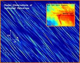
Scientists track individual raindrops inside clouds

(Phys.org) -- Naval Research Laboratory (NRL) scientists are leading a multi-agency study which reveals that a very high-resolution Doppler radar has the unique capacity to detect individual cloud hydrometeors in the free atmosphere. This study will improve scientists' understanding of the dynamics and structure of cloud systems.
This Doppler radar was previously used to track small debris shed from the NASA space shuttle missions during launch. Similar to the traces left behind on film by sub-atomic particles, researchers observed larger cloud particles leaving well-defined, nearly linear, radar reflectivity “streaks†which could be analyzed to infer their underlying properties. Scientists could detect the individual particles because of a combination of the radar's 3MW power, narrow 0.22 degree beamwidth, and an unprecedented range resolution as fine as 0.5m. This combination of radar attributes allows researchers to sample a volume of cloud about the size of a small bus (roughly 14 m3) when operating at a range of 2 km. With such small pulse volumes, it becomes possible to measure the properties of individual raindrops greater than 0.5mm in diameter due to the low concentration of such drops in naturally occurring cloud systems and the overwhelming dominance such drops have on the measured radar reflectivity when present in a field comprised of smaller particles.
The study was carried out as a multi-agency effort with scientists from NRL's Marine Meteorology Division, located in Monterey, California, as well as the Scripps Institution of Oceanography, the Naval Surface Warfare Center Dahlgren Division, the Johns Hopkins University Applied Physics Laboratory, L-3 Interstate Electronics Corp, Radar Technology Specialists Corp., Weather Modification, Inc., and students as far away as the Institute of Geophysics located at the University of Warsaw. This team of specialists, spanning an area of expertise from cloud physics and dynamics to radar theory, design, and applications, assembled to conduct a series of weather experiments held in coordination with the Naval Ordinance Test Unit, the Federal Aviation Administration, Cape Canaveral Air Force Station Facility, and NASA between 2008 and 2010.
The purpose of these experiments was to study the properties of various cloud systems as well as to evaluate the ability of the U.S. Navy's Mid-Course Radar (MCR) to retrieve information on the cloud's internal flow and precipitation structure. Toward this end, the team conducted field projects during the height of the Florida summer convective season in order to collect radar data, launch weather balloons, obtain in situ cloud data using an instrumented research aircraft, and to document other features of the local cloud systems using a variety of complimentary surfaced-based sensors such as an upward looking lidar and all-sky camera. These additional instruments were used to continuously monitor the sky conditions as well as to help guide the precise placement of the aircraft and the high-resolution MCR radar beam during the numerous case events documented during the course of the experiment.
The purpose of these experiments was to study the properties of various cloud systems as well as to evaluate the ability of the U.S. Navy's Mid-Course Radar (MCR) to retrieve information on the cloud's internal flow and precipitation structure. Toward this end, the team conducted field projects during the height of the Florida summer convective season in order to collect radar data, launch weather balloons, obtain in situ cloud data using an instrumented research aircraft, and to document other features of the local cloud systems using a variety of complimentary surfaced-based sensors such as an upward looking lidar and all-sky camera. These additional instruments were used to continuously monitor the sky conditions as well as to help guide the precise placement of the aircraft and the high-resolution MCR radar beam during the numerous case events documented during the course of the experiment.
In addition to Dr. Schmidt, the NRL research team members include Dr. Paul Harasti and Dr. Piotr Flatau, who is an on-site faculty member from Scripps Institute of Oceanography. The finding is published in the June 12, 2012 issue of the Proceedings of the National Academy of Sciences where the list of remaining authors and their contributions to the study may be found.
Journal information: Proceedings of the National Academy of Sciences
Provided by Naval Research Laboratory


