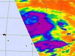
NASA satellite sees Tropical Storm Sanvu pass Guam, strengthen

Tropical Depression 03W in the western North Pacific did exactly what forecasters expected over the last twenty-four hours: it became a tropical storm named Sanvu and passed west of Guam on a northwesterly track.
On May 22 at 0900 UTC (5 a.m. EDT), Tropical Storm Sanvu was more than 100 miles west-northwest of Andersen Air Force Base, Guam, and still over 600 nautical miles south of Iwo To, Japan and headed in that direction. Sanvu's center was located near 15.2 North and 141.9. East. It was still churning up rough surf around Guam. Sanvu has maximum sustained winds near 45 knots (52 mph/83 kph) with higher gusts. Sanvu is a compact tropical storm, with tropical-storm-force winds extending out 90 miles from the center, making it about 180 miles in diameter.
An infrared image of Tropical Storm Sanvu was captured from the Atmospheric Infrared Sounder (AIRS) instrument onboard NASA's Aqua satellite on May 22, and shows a large area of very strong thunderstorms near the center of circulation. Forecasters at the Joint Typhoon Warning Center noted the AIRS imagery "shows the system has further consolidated and convection has resurged, especially along the northeast flank."
Forecasters expect Sanvu to keep intensifying as it moves closer to Iwo To because of warm sea surface temperatures and light wind shear. Thereafter it is expected to curve to the northeast and transition to an extra-tropical storm.
Provided by NASA's Goddard Space Flight Center


