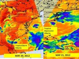
Alberto now a tropical depression

Infrared satellite imagery from NASA's Aqua satellite revealed Alberto weakened from a tropical storm to a tropical depression as it appears more disorganized. At 10:30 a.m. EDT on May 21, Tropical Storm Alberto weakened to a tropical depression, and has maintained that status today, May 22.
As of 5 a.m. EDT on May 22, Alberto's maximum sustained winds were near 35 mph (55 kph) but he is expected to weaken in 24 hours. Alberto was centered about 220 miles south of Cape Hatteras, North Carolina, near 32.0 North and 75.5 West. Alberto was moving to the northeast near 15 mph (24 kph), and had a minimum central pressure of 1008 millibars.
Over two days, NASA's Aqua satellite captured infrared images of Alberto and saw it's deterioration from a tropical storm to a tropical depression. The infrared images were captured from the Atmospheric Infrared Sounder (AIRS) instrument on NASA's Aqua satellite on May 20 and May 21. The coldest cloud top temperatures were as cold as -63F (-52C) and indicated the strongest thunderstorms with the heaviest rainfall.

On May 22, a visible image from NOAA's GOES-15 satellite showed Alberto off the coast of North Carolina. The depression appeared to look almost wedge-shaped as it continues to weaken and move to the northeast. The image was created by the NASA GOES Project at NASA's Goddard Space Flight Center, Greenbelt, Md.
The National Hurricane Center expects Alberto to continue moving northeast and speed up. As Alberto speeds up, it is expected to weaken and could become a post-tropical remnant low pressure area by Wednesday and dissipate by Thursday, May 24.
Provided by NASA's Goddard Space Flight Center


