NASA watches a Gulf Weather system for unusual subtropical development

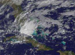
Hurricane season in the Atlantic Ocean and Gulf of Mexico doesn't begin until June 1, 2012, but a low pressure area in the Gulf called System 90L, is being watched on February 5 and 6 for possible development into sub-tropical depression although the chances are now slim to none. Data from the GOES-13 satellite was created into an image at NASA, and it showed System 90L raining on south Florida today.
On Sunday, February 5, at 6:45 p.m. EST the National Hurricane Center (NHC) issued a special tropical weather outlook for System 90L. The outlook stated, "A non-tropical low pressure system interacting with an upper-level trough (elongated area of low pressure) is producing widespread cloudiness...showers...and scattered thunderstorms across much of western and central Cuba...the lower Florida keys...and adjacent waters of the northwestern Caribbean Sea...southeastern Gulf of Mexico...and the Florida Straits." At that time, System 90L was located just west of Cuba's western tip and the NHC gave it a 30 percent chance of becoming a subtropical cyclone.
By Monday, February 6 at 7 a.m. EST, System 90L extended from western Cuba northward into the Florida straits and it was interacting with a mid-to-upper-level trough (elongated area of low pressure). Because there are no signs of organized surface circulation, the NHC has dropped the chance that the system will develop into a subtropical depression to near zero.
NOAA's GOES-13 satellite captured a visible image of System 90L in the eastern Gulf of Mexico on Monday, February 6, 2012. The image was created by NASA's GOES Project at the NASA Goddard Space Flight Center in Greenbelt, Md. NOAA operates the GOES series of satellites, and NASA's GOES Project creates imagery and animations from the satellite data. In the image, System 90L appeared as the somewhat rounded area of clouds over Florida's southern peninsula. Some of the thunderstorms in the northwestern quadrant of System 90L appeared to be higher (they cast shadows on the clouds around them) and were likely stronger with heavy rain.
Even though the chance for development into a pre-season subtropical storm is now near zero, System 90L is expected to bring widespread heavy rainfall and some gusty winds over northern Cuba, the Florida Keys and south Florida on Monday, February 6. The National Weather Service issued a hazardous weather outlook on February 6 for Miami that calls for locally heavy rain with a slight risk of thunderstorms. Thunderstorms may contain gusty winds and occasional lightning strikes. There is also a slight risk of rip currents at the Palm Beach County beaches on Florida's east coast.
System 90L is moving to the northeast at about 15 mph and is creating a very wet start to the week in southern Florida.
Provided by NASA's Goddard Space Flight Center


