GOES-13 satellite sees 'giant white spike' of clouds bringing U.S. severe weather
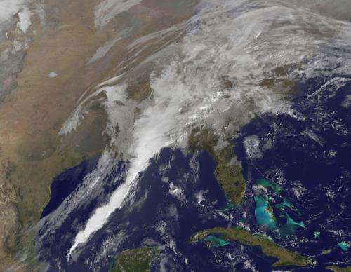
(PhysOrg.com) -- Severe weather is expected to impact the southeastern U.S. today, and the GOES-13 satellite captured an image of a line of clouds associated with the strong cold front that looks like a giant white spike.
This same frontal system brought heavy rain, flooding and tornadoes to Texas yesterday, January 25. Severe weather occurred from San Antonio to Dallas and Fort Worth as the strong cold front pushed through. Dallas reported flooding up to three feet high in some areas. Wind gusts were reported as high as 50 mph.
More severe weather is expected east of the Lone Star State today, January 26, as the line of clouds associated with a strong cold front pushes east. The front is now pushing through Louisiana, Mississippi, Alabama, and western Florida triggering more severe weather warnings and watches.
NOAA's geostationary operational environmental satellite, GOES-13, serves the eastern half of the U.S. providing continuous weather imagery. There is also GOES-15 that covers the western half of the U.S. Both GOES satellites are not only used for weather applications, but also track space weather, oceanographic changes, forest fires and other hazards and provide scientific data collection and information for search and rescue operations. NASA's GOES Project, located at NASA's Goddard Space Flight Center in Greenbelt, Md. creates images and animations from the GOES satellites. The image from today, January 26 was captured at 1331 UTC (8:31 a.m. EST). The line of thunderstorms associated with that cold front looks like a giant solid white spike moving through the southern U.S.
States that may experience severe weather today, January 26, 2012, including tornadoes include Louisiana, Mississippi, Alabama, Georgia and the Florida panhandle. Severe weather is possible today from New Orleans, La. to Jackson, Miss. west to Birmingham, Ala., south to Mobile, Ala. and east to Pensacola, Fla., and into south and central Georgia.
Severe thunderstorm warnings were in effect during the morning hours today for a number of those areas. Gusty winds to 60 mph, heavy rain, frequent lightning, small hail and tornadoes are possible in those areas.
Provided by JPL/NASA


