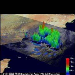
TRMM Satellite sees Tropical Storm Keila form in the Arabian Sea

The TRMM satellite passed directly above a recently formed tropical cyclone in the Arabian Sea on November 2, 2011 at 0350 UTC (11:50 p.m. EDT, Nov. 1). An analysis of rainfall was done using TRMM's Microwave Imager (TMI) and Precipitation Radar (PR) instruments. TRMM data showed that rainfall rates with tropical storm Keila ranged from light to moderate along the south-eastern coast of Oman. Moderate to heavy rainfall was revealed to be spiraling into Keila's center of circulation in the Arabian Sea near the southeastern coast of Oman.
TRMM Precipitation Radar data was used to create a 3-D vertical structure of Tropical Storm Keila. It showed that a few towers near Keila's center were reaching heights of about 13 km (~8.1 miles). Powerful storms were shown in a large feeder band converging into Kelia from the Arabian Sea.
At 1500 UTC (11 a.m. EDT) today, Nov. 2, Tropical Storm Keila had maximum sustained winds near 35 knots (40 mph). Keila's center was over the Yemen coast and about 630 nautical miles northeast of Aden, Yemen. It was near 17.0 North and 54.9 East. Although Keila was moving at 5 knots (6 mph) to the northeast, a building mid-level ridge (elongated area) of high pressure is building to the north of the storm, and will re-route it to the west-southwest.
Also this morning, infrared data from the Atmospheric Infrared Sounder (AIRS) on NASA's Aqua satellite saw a burst of convection (developing thunderstorms) around the center of circulation and a band of thunderstorms to the south of the center.
Keila is expected to weaken a little as it continues to interact with the coastline, but slowly intensify tomorrow or Friday because of warm sea surface temperatures.
Keila made landfall early today (Nov. 2) in Oman, and is forecast to track to the west-southwest along the Oman and Yemen coastlines.
Provided by NASA's Goddard Space Flight Center


