NASA satellites 'eyes' changes in Hurricane Katia

Major Hurricane Katia continues to approach the U.S. East coast and stir up rough surf. Meanwhile two NASA satellites have provided a look at the changes in organization and cloud patterns over the last several days.
One NASA instrument that flies aboard two different NASA satellites has been providing very clear pictures of Hurricane Katia's transition over the last couple of days. The Moderate Resolution Imaging Spectroradiometer or MODIS instrument flies on NASA's Aqua and Terra satellites.
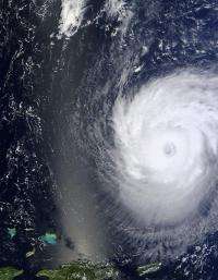
At 11:00 a.m. AST, September 2, Hurricane Katia had winds of 75 miles per hour with higher gusts when MODIS captured a natural color image of her. The image was taken by the MODIS instrument on NASA's Aqua satellite at 12:25 p.m. AST when Katia was east of the Leeward Islands. Although the hurricane lacked a distinct eye, it sported the spiral shape characteristic of strong storms.
Two days later, the MODIS instrument on NASA's Terra satellite captured a visible image of Hurricane Katia and her eye was completely cloud-filled. Then, on Sept. 5 at 11:30 a.m. EDT, when Katia was a major hurricane in the Atlantic Ocean, some of the cloud cover cleared over her eye as a testament to her major hurricane status.
On Sept. 6, Hurricane Katia appeared less symmetric and once again, her eye was less obvious. Satellite imagery indicated a double-eyewall within the storm, suggestions that Katia is undergoing eyewall replacement again (which happens in major hurricanes).
The National Hurricane Center noted that "the large-scale atmospheric and oceanic environment are likely to remain conducive for Katia to maintain major hurricane status."
At 5 a.m. EDT on Sept. 6, Hurricane Katia's maximum sustained winds were near 125 mph with higher gusts. That makes Katia a Category 3 hurricane on the Saffir-Simpson scale and a major one. Katia was about 400 miles (645 km) south of Bermuda near latitude 26.5 north and longitude 65.1 west. Katia is moving toward the northwest near 10 mph (17 km/h) and will continue in that direction one more day before turning to the north-northwest by Thursday.
A slow-moving cold front and the remnants of Tropical Storm Lee are blocking powerful Hurricane Katia from coming closer to the U.S. However, Katia is close enough to create rough and hazardous surf and rip currents along the U.S. east coast. Bermuda, the greater Antilles and east-facing beaches of the Bahamas are also expected to experience large and dangerous swells, rip currents and life-threatening surf over the next several days.
Provided by NASA's Goddard Space Flight Center


