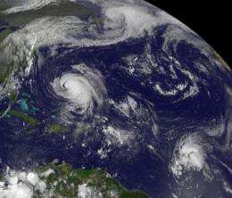
NASA panorama sees Tropical Storm Maria join Hurricane Katia

Newborn Tropical Storm Maria joined Hurricane Katia in the Atlantic Ocean today. Both storms were seen on an impressive panoramic satellite view from the GOES-13 satellite, one in the central Atlantic, and the other in the western Atlantic near the U.S.
An image from NOAA's GOES-13 satellite today showed newborn Tropical Storm Maria about 1305 miles (2,095 km) east of the Lesser Antilles this morning, Sept. 7, at 11 a.m. EDT. The National Hurricane Center (NHC) reported Maria's center near 13.0 North and 42.0 West. Maria's maximum sustained winds were near 50 mph and is expected to strengthen over the next two days. Maria is moving to the west near 23 mph (37 kmh) and this general motion is expected to continue during the next two days. Estimated minimum central pressure is 1003 millibars. Currently, Maria is no threat to land but could pose a threat to the Lesser Antilles this weekend.
GOES-13 captured a panorama of the Atlantic Ocean today, as it does every day. Today, however, it revealed clouds associated with tropical Storm Lee's remnants over the U.S. east coast, Hurricane Katia is moving between Bermuda and the U.S., while farther east is newborn Tropical Storm Maria. The GOES image was created at NASA's GOES Project, located at NASA's Goddard Space Flight Center, Greenbelt, Md.
Hurricane Katia appears much more impressive on the GOES-13 satellite imagery because she's a Category one hurricane on the Saffir-Simpson scale with maximum sustained winds near 85 mph. Although a hurricane, today's GOES-13 image did not reveal an eye in visible imagery.
Katia has prompted a tropical storm watch for Bermuda. At 11 a.m. EDT on Sept. 7, Katia's center was about 320 miles (515 km) southwest of Bermuda near 29.2 North and 68.8 West. It was moving toward the northwest near 10 mph (17 kmh) and is expected to turn toward the north-northwest then north-northeast tomorrow, moving between the eastern U.S. and Bermuda. Katia is about 410 miles in diameter, so tropical storm force-winds were already reaching Bermuda this morning.
The NHC continues to warn of large swells created by Katia to affect most of the U.S. east coast, Bermuda and greater Antilles. Katia is forecast to generate 1 to 2 inches of rain over Bermuda.
While all eyes are on Katia today as she affects Bermuda, forecasters will later be turning their attention to Maria who will be closing in on the Caribbean.
Provided by NASA's Goddard Space Flight Center


