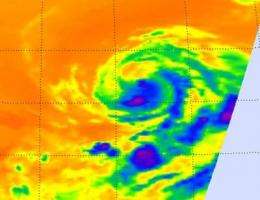
NASA sees warmer cloud tops in infrared imagery of Tropical Storm Eugene

Warmer cloud top temperatures mean that cloud heights in a tropical cyclone are dropping and the storm doesn't have as much power to push them higher in the atmosphere. That's what NASA infrared satellite imagery has revealed about Tropical Storm Eugene this morning.
During the very early morning hours (Eastern Daylight Time) on August 5, Eugene was still hurricane strength. Then the storm ran into cooler waters and a more stable atmosphere, weakening into a tropical storm.
That weakening was confirmed in satellite imagery from the Atmospheric Infrared Sounder (AIRS) instrument (that flies on NASA's Aqua satellite) on August 5 at 10:05 UTC (6:05 a.m. EDT). Infrared imagery basically takes an object's temperature. The AIRS infrared image showed that the cloud top temperatures had warmed since midnight, indicating that the cloud heights dropped and the power behind the uplift that creates the thunderstorms had waned quickly.
At 11 a.m. EDT (8 a.m. PDT) on August 5, Tropical Storm Eugene's maximum sustained winds were near 65 mph (100 kmh). It was located at sea near 17.9 North and 123.3 West, about 935 miles (1500 km) west-southwest of the southern tip of Baja California. Eugene was still moving to the west-northwest at 13 mph (20 kmh) and had a minimum central pressure of 996 millibars.
The National Hurricane Center expect that Eugene will become a remnant low by Sunday, August 7 as it continues to move into a more stable environment and cooler waters.
Provided by NASA's Goddard Space Flight Center


