NASA continues tracking soaking remnants of Hurricane Irene into Canada

Hurricane Irene left a trail of devastation and heavy rainfall in its wake from the Caribbean to the U.S. east coast and is now a depression dumping heavy rains in eastern Canada before it heads into the Atlantic. Satellite imagery from NASA and NOAA continue to show the progression of Irene's remnants today and her massive size and the TRMM satellite gave insight into her weakening condition.
From Puerto Rico to the Bahamas, and in the U.S. from North Carolina to Vermont Hurricane Irene was a huge rainmaker, dropping about 16 inches of rain in N.C., Va. and lesser (but large) amounts all the way up to Vermont, where the effect of Irene moving against the Green mountains brought the worst flooding seen there in 75 years.
On Monday, August 29, Vermont's Governor Shumlin told the Weather Channel that as many as 250 Vermont roads were closed from flooding. It is the worst flooding in Vermont since 1927, according to CNN. New Hampshire dealt with the same issues also because of the White Mountains. Whenever a tropical storm or hurricane push up against higher terrain, such as mountains it creates what is called orographic uplift, where air is forced to rise against the mountains and creating more storms, bringing more rain.
On Monday, August 29, 2011 at 5 a.m. EDT, tropical depression Irene were moving into Quebec and Newfoundland, Canada and causing major flooding in New Hampshire and Vermont. Irene's maximum sustained winds were around 35 mph (55 kmh). It was centered about 100 miles (165 km) northwest of Houlton, Maine near 47.4 North and 68.8 West. It was moving to the north-northeast near 25 mph (40 kmh) and had a minimum central pressure of 981 millibars. Flood warnings and high wind warnings remain in effect for parts of the northern Mid-Atlantic into New England as rivers continue to move floodwaters downstream.

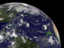
NOAA's GOES-13 satellite captured an image of Irene's huge area of remnant clouds and rainfall over northern New England and eastern Canada today at 7:45 a.m. EDT. Her remnants were bringing gusty winds and heavy rainfall on parts of Quebec and in the Maritime provinces. Just as she did in the Caribbean and eastern U.S. Irene is causing a lot of downed trees and power outages. Montreal has reported thousands of outages according to Hydro-Québec.
CBC News reported at 8 a.m. EDT today that Irene was centered about 34 miles (55 kilometers) south-southeast of Baie Comeau, Quebec. Irene is moving toward Labrador. Currently there are wind warnings in effect for Prince Edward Island and portions of Quebec. CBC reported that almost 2 inches (50 millimeters) of rain had fallen in southern New Brunswick by Sunday afternoon and there were over 50,000 residents without electricity there.
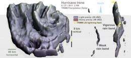
On Saturday afternoon August 27, the Tropical Rainfall Measuring Mission (TRMM) satellite provided forecasters with clues that Irene's winds were about to weaken. TRMM, a satellite managed by NASA and the Japanese Space Agency, JAXA flew over Hurricane Irene after it made landfall in North Carolina.
According to Owen Kelley of the TRMM team at NASA's Goddard Space Flight Center, TRMM provided multiple pieces of evidence that showed Irene was weakening at the time: The eye had filled, i.e., there was precipitation inside it; the eyewall contained no regions of heavy precipitation, that was there in earlier images; the eyewall precipitation reached less high in altitude on this overflight than in previous overflights (5.6 miles vs. 7.5 miles) (~9 km vs. ~12 km); and the only lightning observed by the TRMM LIS was in an outer rain band, over 300 kilometers (180 miles) away from the eye. The absence of lightning in the inner core of Hurricane Irene at landfall suggests that the fastest inner-core updrafts were not as vigorous as they had been on previous days.
Provided by NASA's Goddard Space Flight Center


