NASA sees Tropical Storm Meari headed for North Korea landfall

There are going to be two landfalling tropical cyclones in the Northwestern Pacific Ocean basin this weekend, Haima in Vietnam and Tropical Storm Meari in North Korea. NASA infrared satellite imagery today shows the Meari is stronger than Haima.
Tropical Storm Haima has maximum sustained winds near 35 knots (40 mph/65 kmh) making it a minimal tropical storm tracking toward Vietnam. Tropical Storm Meari is a stronger storm, with maximum sustained winds near 55 knots (63 mph/101 kmh). At 1500 UTC (11 a.m. EDT) on June 24 Meari's center was about 250 nautical miles southwest of Kadena Air Base, Japan near 23.9 North and 125.0 East. It was moving northwest near 12 knots (14 mph/22 kmh).
The Joint Typhoon Warning Center noted that this morning, June 24, 2011, Kadena, Futenma, and Naha Okinawa, Japan have reported sustained southeasterly winds greater than 20 knots (23 mph/37 kmh).
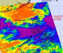
NASA's Aqua satellite passed over the western half of Tropical Storm Meari on June 24 at 05:29 UTC (1:29 a.m. EDT) and captured an infrared image of the storm's cloud top temperatures using the Atmospheric Infrared Sounder (AIRS) instrument. AIRS showed that most of Meari's heaviest thunderstorms were over the waters of the South China Sea and stretched west into Luzon, Philippines. The infrared image also revealed thick low-level banding of thunderstorms wrapping around the center of circulation and the strongest convection (rapidly rising air that forms thunderstorms) was located over the northern half of Meari.
Forecasters at the Joint Typhoon Warning Center expect Meari to strengthen as much as 10 knots over the next day as wind shear wanes, before it increases and weakens the storm prior to landfall. It is expected to make landfall in southwestern North Korea on June 26 with sustained winds near 40 knots (46 mph/74 kmh).
Coastal areas in western North and South Korea, and eastern China can expect rough surf as Tropical Storm Meari tracks through the Yellow Sea over the next two days. Southwestern North Korea and northwestern South Korea will experience heavy rainfall and possible flooding as Meari comes ashore this weekend.
Provided by NASA's Goddard Space Flight Center


