Eye say, Adrian is still a powerful hurricane on NASA satellite imagery

Hurricane Adrian has been good at hiding his eye from satellite imagery over the last two days, but the latest Aqua and GOES-13 satellite imagery provides the best look at the eye, despite some overcast inside.
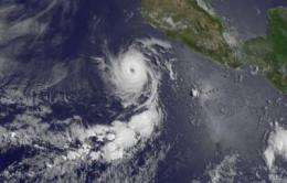
The Geostationary Operational Environmental Satellite called GOES-11 captured a visible image of Major Hurricane Adrian on June 10 at 1601 UTC (12:01 p.m. EDT).The image, that shows the eye of the storm with some dense overcast in it, was made at the NASA GOES Project out of NASA Goddard Space Flight Center, Greenbelt, Md. GOES-13 is managed by NOAA.
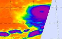
When NASA's Aqua satellite passed overhead on June 10 at 09:17 UTC (5:17 a.m. EDT) the Atmospheric Infrared Sounder (AIRS) instrument took an infrared image of Adrian. AIRS images are false colored to show cloud temperature where purple colorations indicate the highest, coldest cloud top temperatures (usually colder than -63F/-52C). Today's image showed a large area of those cold cloud tops (indicating strong thunderstorms around the center of the storm) with warmer cloud temperatures (in blue) in the center - revealing an eye.

At 8 a.m. PDT (11 a.m. EDT), Hurricane Adrian had maximum sustained winds near 135 mph (215 kmh) and was located about 375 miles (600 km) south-southwest of Cabo Corrientes, Mexico near 15.3 North and 107.6 West. It was moving away from land to the west-northwest at 9 mph (15 km/h) and had a minimum central pressure of 948 millibars.
Adrian is expected to stay at sea but will continue to stir up rough surf along the southwestern coast of Mexico through the early part of the weekend.
Provided by NASA's Goddard Space Flight Center


