System 92E looking more like a developing east Pacific tropical storm

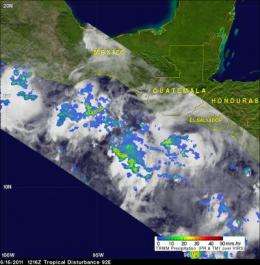
A low pressure area in the Eastern Pacific Ocean, located off the western coast of Mexico, is still getting organized, and System 92E and the Tropical Rainfall Measuring Mission (TRMM) satellite spotted heavy rain and strong thunderstorms within.
On Friday, June 17, 2011, System 92E appeared on satellite imagery as a broad area of low pressure that contained showers and thunderstorms. System 92E was located several hundred miles south of the Gulf of Tehuantepec. The gulf is a large area at 16 North and 95 West, which is right where the low pressure area is centered. Many tropical cyclones in the Eastern Pacific get organized near or in the Gulf.
The National Hurricane Center (NHC) noted today that the environmental conditions (warm sea surface temperatures and light vertical wind shear) are favorable for development, and they give System 92E a Medium chance for development over the weekend.
The TRMM satellite, co-managed by NASA and the Japanese Space Agency always watches the tropics, and flew over System 92E on June 16 at 1216 UTC (8:16 a.m. EDT). At that time, TRMM's Microwave Imager (TMI) and Precipitation Radar (PR) data showed moderate to heavy rainfall in clusters of thunderstorms parallel to the coastlines of southern Mexico, Guatemala and El Salvador.
Today, June 17, the NHC reported scattered moderate and isolated strong convection was flaring up in System 92E within 90 nautical miles of 13 North and 93 West, along the coast of El Salvador and Guatemala. The NHC forecasts the low pressure area to drift west over the weekend and possibly strengthen into a tropical storm. If System 92E does become a tropical storm it would get the name "Beatriz."
On June 13, the remnants of the once Major Hurricane Adrian finally dissipated in the Eastern Pacific.
Over the weekend El Salvador, Guatemala, and southern Mexico can expect showers and thunderstorms from this system as it moves and organizes.
Provided by NASA's Goddard Space Flight Center


