Volcano study lays foundations for ancient maps

Research into submarine volcanoes in the Pacific Ocean will lay the groundwork for scientists to map the Earth as it was millions of years ago.
An international team of scientists has just returned from a two-month expedition to the Louisville Seamount Trail, a 4300km-long chain of extinct, underwater volcanoes 1500km northeast of New Zealand.
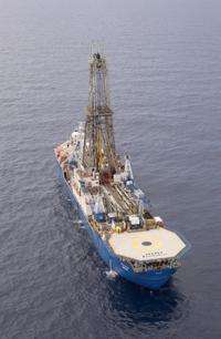
University of Queensland geochronologist Benjamin Cohen and Australian National University earth scientist David Buchs worked on board the research vessel JOIDES Resolution, the flagship of the multi-million-dollar Integrated Ocean Drilling Program. The JR set sail from Auckland Harbour on December 17 and returned last Friday (Feb 11).
The Louisville volcanoes are thought to have been punched through the Pacific oceanic plate between 80 million and one million years ago as the plate passed over a hotspot – a plume of material originating from a region deep within the mantle.
Hotspots are normally regarded as fixed in relation to the moving plates. Scientists have used them as reference frames to trace the movement of the crustal plates, at rates of up to 100 millimetres a year, through geologic time.
Plate tectonics resulted in the break-up of ancient supercontinents, such as the huge southern landmass Gondwana, comprising Australia, Antarctica, South America, India and Africa.
“However, recent research revealed that the hotspot that created the Hawaiian-Emperor chain of volcanoes to the north of the Louisville Seamount Trail might not have been stationary, but had moved about 15 degrees southward between 80 million and 50 million years ago,” said Dr Cohen, of UQ's School of Earth Sciences.
“This has raised questions over whether these two Pacific plate hotspots can be used as fixed frames of reference.”
Technicians on the research expedition drilled cores up to 522m deep, into five Louisville volcanoes. The operation was performed in water depths of between 1200 and 2000m. The team recovered more than 800 metres of core material, comprising volcanic and sedimentary rocks.
The scientists will now begin analyzing the material, using advanced techniques.
“This will tell us the ages of the Louisville volcanoes and the latitude at which they formed,” Dr Cohen said.
“We will compare this information with the present hotspot location to see if the Louisville plume is fixed in the mantle or if it moves, as the Hawaiian hotspot seems to do.”
One possibility is that the two hotspots have moved in concert, and could act as a moving frame of reference.
The results are expected to help other scientists reconstruct the geography of the planet as it was in the deep past.
Dr Buchs said previous studies on rocks dredged from the Louisville chain indicated the composition of the hotspot had been remarkably homogenous for up to 80 million years.
“Perhaps the volcanic activity that formed the Louisville chain differs from that responsible for other hotspot volcanoes, such as the Hawaiian-Emperor Seamounts, which show more geochemical variation,” he said.
“We obtained samples from different levels of the volcanoes, and this might provide key insights into their magmatic evolution. This will shed light on the dynamic processes in the Earth's mantle.”
The team also collected sediments deposited on the Louisville volcanoes.
“The study of these sediments will give insights into oceanographic and climatic change in the southern hemisphere 80 to 60 million years ago,” said Dr Buchs.
The expedition comprised scientists from nine nations, and was led by co-chief scientists Associate Professor Anthony Koppers, of Oregon State University, USA, and Dr Toshitsugu Yamazaki, of the National Institute of Advanced Industrial Science and Technology and the Geological Survey of Japan.
Provided by University of Queensland


