Quick-intensifying Tropical Storm Karl landfalling in Mexico

NASA's Aqua satellite captured the birth of Tropical Storm Karl on Sept. 14 as it passed overhead at 3:05 p.m. EDT in the Caribbean. This morning, Karl made landfall in the east coast of the Yucatan Peninsula, Mexico.
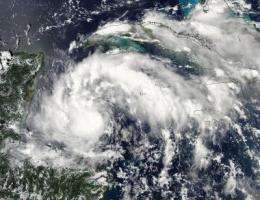
By 5 p.m. EDT on Sept. 14, System 92L intensified quickly in the western Caribbean and became the thirteenth tropical depression that quickly fired up into Tropical Storm Karl. NASA's Aqua satellite was flying overhead at 3:05 p.m. EDT and the Moderate Resolution Imaging Spectroradiometer (MODIS) instrument captured a visible image of Karl as he was rapidly intensifying.
At 8 a.m. EDT Karl's maximum sustained winds were near 65 mph (9 mph less than hurricane strength) as Karl was making landfall on the Yucatan Peninsula of Mexico. It was centered near latitude 18.6 North and longitude 87.6 West. Minimum central pressure is 991 millibars.
Karl is moving toward the west-northwest near 13 mph and he will continue in this direction across the Yucatan Peninsula, moving back into the southwestern Gulf of Mexico on Thursday.
The National Hurricane Center noted this morning, that when Karl moves into the Gulf of Mexico, it is likely that he'll strengthen into a hurricane.

Karl is a small system as tropical storm-force winds currently extend out 45 miles from the center (making him about 90 miles in diameter), however, the rain and storm surge he brings with him will pack a strong punch.
In the 8 a.m. EDT hour, a Mexican automated station at Banco Chinchorro reported sustained winds of 49 mph and a wind gust of 62 mph.
Watches and Warnings are in effect as Karl was approaching landfall this morning. A Tropical storm warning is in effect from Chetumal on the Mexico / Belize border to Cabo Catoche. A Tropical storm watch is in effect fromBelize City north to the Mexico / Belize border.
Where Karl makes landfall, coastal flooding will occur near and north of that location and it will be accompanied by large and battering waves. Rainfall is expected to be heavy over the Yucatan Peninsula, Belize and northern Guatemala, where 3 to 5 inches of rain are expected with isolated amounts up to 8 inches.
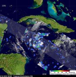
That heavy rainfall was observed yesterday when the Tropical Rainfall Measuring Mission (TRMM) satellite, that is managed by NASA and the Japanese Space Agency, JAXA flew over Karl before he became a tropical storm. During the early morning on Sept. 14, the TRMM satellite noticed some heavy rainfall (falling at more than 2 inches per hour) around the storm's center at 2:19 a.m. EDT yesterday. That rainfall is now happening over the Yucatan Peninsula.
Provided by NASA's Goddard Space Flight Center


