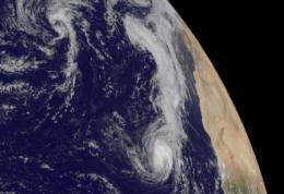
NASA satellites help see ups and downs ahead for Depression Lisa

Tropical Depression Lisa has had a struggle, and it appears that she's in for more of the same.
Infrared satellite imagery from the Atmospheric Infrared Sounder (AIRS) instrument on NASA's Aqua satellite shows that the convection (rapidly rising air that forms thunderstorms that make up a tropical cyclone) is increasing in Lisa. The convection is becoming a little better organized and stronger which is will make for some heavy rainfall over the northwestern Cape Verde Islands. It's also an indication that she may be strengthening back into a tropical storm today.
That increased convection is a sign that Lisa is strengthening a little, and that's what the National Hurricane Center is forecasting for the next 24 hours, although there is some dry air nearby in the mid-levels of the atmosphere that Lisa is contending with. Dry air saps the warm, moist "fuel" from tropical cyclones.
So, after 24 hours, Lisa is expected to run into another hurdle. In fact, several hurdles: dry air, cooler sea surface temperatures (AIRS can see those, too) and increasing wind shear from the west. Those are three factors that weaken tropical storms, so Lisa is under a "triple header" threat from her environment after Friday.
As of 11 a.m. EDT on Sept. 23, Tropical Depression Lisa's maximum sustained winds were near 35 mph. It was located about 340 miles west-northwest of the Cape Verde Islands near 17.5 North and 28.9 West. It was drifting at 2 mph to the north. Lisa's minimum central pressure was 1005 millibars.
The latest satellite imagery from the GOES-13 satellite (the Geostationary Operational Environmental Satellite) at 1445 UTC (10:45 a.m. EDT) on Sept. 23 shows Lisa off the western coast of Africa as a rounded circulation.
GOES-13 is operated by the National Oceanic and Atmospheric Administration, and images are created by NASA's GOES Project, located at NASA's Goddard Space Flight Center, in Greenbelt, Md. While Lisa is powering back up, the remnant circulation of former Tropical Depression Julia is located about 750 miles southwest of the Azores islands and there's only a ten percent chance that system will redevelop over the weekend.
Provided by NASA's Goddard Space Flight Center


