NASA uses 3 satellites to see strengthening Tropical Storm Nicole

NASA is providing data from three satellites to give forecasters valuable information on newly strengthened Tropical Storm Nicole. Nicole was Tropical Depression 16 until 11 a.m. EDT, Sept. 29 and NASA data helped confirm her new designation. Satellite data from NASA showed frigid thunderstorm cloud top temperatures, heavy rainfall, and extensive cloud cover as Nicole strengthened.
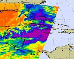
The Atmospheric Infrared Sounder (AIRS) instrument uses infrared technology to take a tropical cyclone's temperature. AIRS sits on NASA's Aqua satellite and captured an image of those cloud top temperatures on Sept. 29 at 0723 UTC (3:23 a.m. EDT) revealing very high thunderstorms around Nicole's center, colder than -65 Fahrenheit.
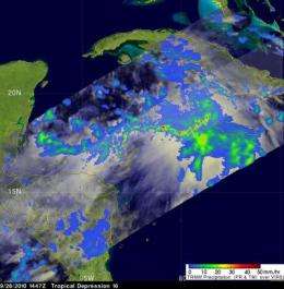
NASA's Tropical Rainfall Measuring Mission satellite (a satellite shared with the Japanese Space Agency) captured the rainfall within Nicole on Sept. 28 as 1447 UTC (10:47 a.m. EDT) when she was Tropical Depression 16, and at that time noticed several areas of very heavy rainfall, falling at a rate of more than 2 inches per hour around the south and eastern sides of the storm's center of circulation. That heavy rainfall continues today, Sept. 29. TRMM will be closely monitoring Nicole with the expected accumulations of 5 to 10 inches over the Cayman Islands, Jamaica and Cuba and even isolated amounts up to 20 inches are possible over the higher elevations of Cuba and Jamaica.

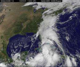
The Geostationary Operational Environmental Satellite called GOES-13 captured a visible image of Tropical Storm Nicole today, Sept. 29 at 1432 UTC (10:32 a.m. EDT). GOES satellites are managed by NOAA. NASA's GOES Project at NASA's Goddard Space Flight Center in Greenbelt, Md. creates images and animations from the satellite data and created today's image that shows the extensive cloud cover (which is also associated with an elongated area of low pressure called a trough) extending north into the Mid-Atlantic U.S. states. The imagery also showed relatively clear skies over the eastern Atlantic which is due to a high pressure area stationed there, which is forcing Tropical Storm Nicole to the north.
At 11 a.m. EDT, Tropical Depression 16 strengthened into Tropical Storm Nicole. Nicole's maximum sustained winds were near 40 mph. Satellite data is observed the strongest winds in Nicole are occurring in the south and southeastern quadrants of the storm. It was centered near Cuba, about 120 miles east-southeast of Havana, Cuba or 260 miles southwest of Nassau, the Bahamas near 22.6 North and 80.6 West. Nicole was moving northeast near 9 mph. It had a minimum central pressure of 996 millibars.
The National Hurricane Center now expects Nicole to stay just east of Florida, so all of the watches and warnings for Florida have been dropped. On the forecast track the center of Nicole will move over the florida straits during the afternoon today (Sept. 29) and move near or over the northwestern Bahamas tonight. Tropical Storm warnings that are in effect include the Cayman Islands, Provinces of Cuba from Matanzas eastward to Ciego de Avila and the northwestern and central Bahamas.
What's in Store for the Cayman Islands, Jamaica, Cuba and Florida?

The National Hurricane Center has noted that Nicole is going to drop extreme amounts of rainfall. Nicole is expected to produce total rain accumulations of 5 to 10 inches over the Cayman Islands, Jamaica and Cuba. Isolated maximum amounts of 20 inches are possible over the higher elevations of Cuba and Jamaica. These rains could cause life-threatening flash floods and mud slides. Rain accumulations of 4 to 8 inches are possible over portions of southern Florida, the Florida Keys and the central and northwest Bahamas. Tropical storm conditions are expected in the warning areas today and tonight. Also, isolated tornadoes are possible along the immediate coast of southeastern Florida and the Florida Keys today.
Nicole is expected to become an extra-tropical storm later today and move northward along the U.S. east coast over the next couple of days.
Provided by NASA's Goddard Space Flight Center


