NASA satellite measures monstrous Hurricane Igor as a '10 hour drive'

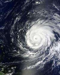
Hurricane Igor is a monster hurricane in terms of strength and size. To get a perspective on its size, it is the same distance from one end of the storm to the other as it is from Boston, Mass. to Richmond, Va., some 550 miles. That's a 10-hour drive from one end to the other, and NASA satellites captured that entire distance in one image.
Because Hurricane Igor is a large storm and even if Igor doesn't make a direct landfall in Bermuda, the extent of the winds (the wind field) is so large that the National Hurricane Center noted that Bermuda can be buffeted by winds of hurricane-force or tropical storm-force on its current track.
Maximum sustained winds this morning were near 145 mph, and although the hurricane-force winds extend outward from the center up to 45 miles (90 miles in diameter), tropical-storm-force winds extend as far as 225 miles (550 miles in diameter). Igor is expected to be close to Bermuda within the next 3 to 4 days.
Hurricane Igor was captured in one image from the Moderate Resolution Imaging Spectroradiometer (MODIS) Instrument that flies aboard NASA's Terra satellite at 1420 UTC (10:20 a.m. EDT) on Sept. 14. The image showed the massive extent of Igor's cloud cover, stretching over 500 miles. The image also showed that Igor's eye was covered with high clouds.

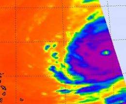
At 5 a.m. EDT on Sept. 15, infrared imagery from NASA's Atmospheric Infrared Sounder (AIRS) instrument indicated that the cloud tops had warmed over the western part of the center, and that Igor's eye had cooled. That indicates slight weakening, because higher, colder cloud tops indicate strong convection (rapidly rising air that forms the thunderstorms that power Igor) and when they warm that means that convection has waned. Infrared imagery from AIRS on Sept. 14 at 1723 UTC (1:23 p.m. EDT) continued to show strong convective activity in his center as indicated by high thunderstorms that were as cold as -63F. Since that time, cloud tops have warmed.
At 0352 UTC this morning (11:52 p.m. EDT Sept. 14) NASA's Tropical Rainfall Measuring Mission satellite showed that the southwestern part of the eyewall has eroded, further confirming the weakening that the infrared data showed. However, the National Hurricane Center noted that Igor is still in a good environment for strengthening.
On Sept. 15 at 5 a.m. EDT, Hurricane Igor was still a powerful Category 4 hurricane on the Saffir-Simpson scale with maximum sustained winds of 145 mph. It was about 1,090 miles southeast of Bermuda, near 19.5 North and 54.5 West. Igor was moving west-northwest near 10 mph and had a minimum central pressure of 935 millibars.
Igor is expected to run into southerly wind shear in 3 to 4 days, which may cause some weakening. NASA satellites will watch for those signs as Igor continues moving through the Atlantic Ocean this week.
Provided by NASA's Goddard Space Flight Center


