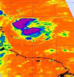
NASA infrared data sees convection building in Fiona's clouds

Infrared satellite imagery from NASA's Aqua satellite showed some strong convection building in Tropical Storm Fiona, and her maximum sustained winds increased from 40 mph yesterday to 60 mph this morning
The Atmospheric Infrared Sounder (AIRS) instrument on NASA's Aqua satellite captured an infrared image of Fiona's cold cloud tops on August 31 at 1:05 p.m. EDT and showed two major areas of strong convection (rapidly rising air that forms the thunderstorms that power a tropical cyclone) north and south of the center of circulation. Some of the cloud tops were are cold as -63 degrees Fahrenheit.
Fiona is intensifying as it approaches the Northern Leeward Islands today, so there are watches and warnings in place. A Tropical Storm Warning is in effect for St. Martin and St. Barthelemy. A Tropical Storm Watch is in effect for Antigua, Barbuda, Montserrat, St. Kitts, Nevis, and Anguilla and St. Maarten, Saba, and St. Eustatius.
At 8 a.m. EDT on September 1, Fiona's maximum sustained winds were near 60 mph. It was about 70 miles northeast of Barbuda, near 18.2 North and 60.9 West. It was moving west-northwest near 15 mph with a minimum central pressure of 998 millibars.
The National Hurricane Center noted that tropical storm conditions could spread over portions of the Northern Leeward Islands later this morning and afternoon, and rainfall accumulations of 1 to 3 inches with isolated maximum amounts of 5 inches can be expected over portions of the Northern Leeward Islands.
Provided by NASA's Goddard Space Flight Center


