NASA sees colder cloud-top temps in new Tropical Depression 16, warnings up

NASA's Aqua satellite has peered into the cloud tops of System 96L in the western Caribbean early this morning and noticed that they've become colder and higher, which indicated the storms was strengthening and organizing. Just over eight hours later, the new Tropical Depression 16 was born, and now has the potential to become a tropical storm before it merges with an elongated area of low pressure near the Florida late on Wednesday.
Tropical Depression 16 was officially named this morning, Sept. 28 at 11 a.m. EDT by NOAA's National Hurricane Center in Miami, Fla. Many watches and warnings have also already been posted this morning. At 11 a.m. Tropical Depression 16's center was about 180 miles south of Havana, Cuba and 390 miles south-southwest of Miami, Fla. near 20.6 North latitude and 82.5 West longitude. It is moving north-northeast near 10 mph and had maximum sustained winds near 35 mph. Its minimum central pressure was 1001 millibars.
The government of the Cayman Islands has issued a Tropical Storm Warning for all of the Cayman Islands. The government of Cuba has issued s Tropical Storm Warning for the Cuban provinces from Mantanzas eastward to Ciego De Avila. The government of the Bahamas has issued a tropical storm warning for the Northwestern and Central Bahamas. This Warning Includes the Abacos, Andros Island, Berry Islands, Bimini, Eleuthera, Grand Bahama Island, New Providence, Cat Island, the Exumas, Long Island, Rum Cay, and San Salvador.
In the U.S., Florida is under a Tropical Storm Warning and Watch. A Tropical Storm Warning has been issued for the Florida coast from Jupiter Inlet southward to East Cape Sable, and for all of the Florida Keys, including Florida Bay and the Dry Tortugas. A Tropical Storm Watch has been issued for the west coast of Florida from north of east Cape Sable to Chokoloskee and for the east coast of Florida from north of Jupiter Inlet to Sebastian Inlet.

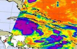
The Atmospheric Infrared Sounder instrument, known as AIRS has the ability to determine cloud top and sea surface temperatures from its position in space aboard NASA's Aqua satellite. Cloud top temperatures help forecasters know if a storm is strengthening or weakening. When cloud top temperatures get colder it means that they're getting higher into the atmosphere which means the "uplift" of warm, moist air is stronger and it will form stronger thunderstorms (that power a tropical cyclone). When cloud-top temperatures warm up it means that the cloud tops are lower than they were before, indicating that the storm is weakening.
When the Aqua satellite passed over Tropical Depression 16 (TD16) from space on Sept. 28 at 0635 UTC (2:35 a.m. EDT) the AIRS instrument took the temperature of the cloud tops in the storm and found them to be as cold as or colder than -63 Fahrenheit throughout a very large area within TD16, indicating the storm had a good amount of energy to power it up. The area of strong thunderstorms in the AIRS images is quite large, and TD16 is already raining on western Cuba.
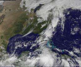
The Geostationary Operational Environmental Satellite known as GOES-13 flew over Tropical Depression 16 on Sept. 28 at 1425 UTC (10:25 a.m. EDT) as it strengthening into a depression. GOES-13's visible imagery showed a large extent of cloud cover, spanning over Cuba and Jamaica, the Cayman Islands and northeastward into south Florida.
The National Hurricane Center (NHC) in Miami, Fla. noted this morning, Sept. 28 at 8 a.m. EDT that TD16 is going to bring some heavy rains and squally conditions in the Caribbean. NHC said, "Heavy rains and strong gusty winds to tropical storm force are expected to affect the Cayman Islands, Jamaica and Cuba today. These weather conditions are likely to spread over the Florida Keys, southern Florida and the northwestern Bahamas later today and Wednesday."
During the morning hours of Sept. 28, the strongest winds were happening about a couple of hundred miles east and south of the Isle of Youth, Cuba and Grand Cayman. If TD16 strengthens into a tropical storm, it would be named Nicole.
South-southwesterly vertical wind shear associated with a large upper-level trough moving into the southeastern U.S. is expected to limit the storm's intensification, although it is near tropical storm-force this morning. The projected track of the TD16 takes it in a north-northeasterly direction across Cuba toward southeastern Florida.
Meanwhile, there's another female named storm that's still making waves in the Atlantic Ocean basin, Julia. However, Julia is just a remnant low pressure area and is about 150 miles south-southeast of Bermuda. This remnant low is moving west-northwest near 15 mph and is not in a good environment for redevelopment. The NHC gives Julia's remnants a meager ten percent chance of redeveloping in the next 48 hours, so TD16 is the one to watch.
Provided by NASA's Goddard Space Flight Center


