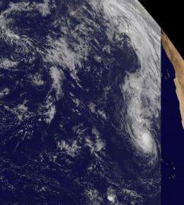
GOES-13 Satellite sees Lisa a tropical storm... for now

The GOES-13 satellite has been keeping an eye on Tropical Storm Lisa and watched her birth, graduation to depression then tropical storm and back to depression. Now, Lisa has grown back to tropical storm status, but it may be short-lived.
At 11 a.m. EDT on Friday, Sept. 24, Tropical Storm Lisa had maximum sustained winds near 50 mph and she may strengthen and weaken over the weekend, but by Sunday colder waters will zap her energy source and she is forecast to be a depression.
Meanwhile, on Sept. 24, she was still frolicking in the eastern Atlantic, about 320 miles northwest of the Cape Verde Islands, near 18.9 North latitude and 27.8 West longitude. Lisa was moving north at 7 mph and is expected to turn north-northwest on Sept. 25. Estimated minimum central pressure is 1000 millibars.
The GOES-13 satellite captured a visible image of Tropical Storm Lisa at 16 45 UTC (12:45 p.m. EDT) on Sept. 24. The GOES visible imagery showed that Lisa now has a well-organized center of circulation, which corresponds with infrared and microwave satellite imagery that showed convection has wrapped around three-fourths of the center of circulation.
The infrared data from the Atmospheric Infrared Sounder (AIRS) instrument on NASA's Aqua satellite today showed that Lisa's thunderstorm cloud tops, north of the center of circulation had cooled down to a frosty -80 Celsius (-112 Fahrenheit), one factor that confirms her re-strengthening. The colder the cloud top temperatures, the higher the thunderstorms, and the more powerful they are. When cloud top temperatures cool, it indicates a strengthening storm. When they warm, a storm is weakening.
Over the weekend, Lisa will move into colder waters and the westerly wind shear will increase ahead of an elongated are of low pressure. The wind shear is forecast to be moderate to strong. So strong that they're expected to "decouple" or separate the low-level circulation from the upper-level circulation in the storm causing it to weaken significantly.
Lisa is expected to become a remnant low pressure system by early next week in the eastern Atlantic.
Provided by NASA's Goddard Space Flight Center


