NASA satellites tracking rain-packed Tropical Storm Chanthu as it heads toward China

NASA satellite imagery of Tropical Storm Chanthu revealed a large area of moderate to very heavy rainfall as it nears the southeast China coast.
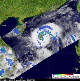
The Tropical Rainfall Measuring Mission (TRMM) satellite flew over Tropical storm Chanthu on July 20 at 1316 UTC (9:16 a.m. EDT) as it churned in the South China Sea. The data it captured helped create a TRMM rainfall analysis to understand the rates in which rain was falling throughout the storm. TRMM is a joint mission between NASA and the Japanese space agency JAXA.
The rainfall analysis was derived from Precipitation Radar (PR) and TRMM Microwave Imager (TMI) data and was overlaid on a TRMM infrared image from Visible and Infrared Scanner (VIRS) data. The rainfall analysis showed a large area of moderate to very heavy rainfall (as much as 2 inches per hour) in Chanthu's southwest quadrant.
Forecasters at the Joint Typhoon Warning Center, the organization that forecasts tropical cyclones in that region, noted "Recent animated multispectral satellite imagery shows spiral banding tightening around a small but persistent area of central convection."
NASA's Aqua satellite captured a visible image of Tropical Storm Chanthu approaching China at 05:45 UTC (1:45 a.m. EDT) on July 21 and it had the signature shape of a tropical storm. No eye was visible.
At 1500 UTC (11 a.m. EDT) on July 21, Tropical Storm Chanthu had maximum sustained winds near 55 knots (63 mph). It was moving north-west at 6 mph (5 knots). At that time, it was about 210 miles south-southwest of Hong Kong, near 19.5 North and 112.2 East.
Chanthu is forecast to pass just north of Hainan Island and make landfall near Luichow Peninsula in the southern China mainland in the evening hours (local time) on July 22 (or mid-morning EDT).
Provided by NASA's Goddard Space Flight Center


