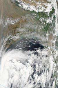
Aqua satellite sees Tropical Storm 1B form in Bay of Bengal

The first tropical storm of the Northern Indian Ocean cyclone season has formed and NASA's Aqua satellite captured its birth. Tropical Storm 1B formed in the early morning hours as the convection around the low level circulation center increased since May 17.
NASA's Aqua satellite captured a visible image of 1B from the Moderate Resolution Imaging Spectroradiometer (MODIS) at 7:25 UTC (12:25 p.m. Asia/Kolkata time) today, May 18, where if formed off of India's east coast in the Bay of Bengal.
At 09:00 UTC (5 a.m. EDT or 2 p.m. Asia/Kolkata local time) on May 18, Tropical Storm 1B had maximum sustained winds near 40 knots (46 mph). It was located about 285 nautical miles east-southeast of Chennai, India near 12.4 North and 84.5 East in the Bay of Bengal. It is moving west-northwest near 13 knots (15 mph) and is forecast to continue in that direction, according to the Joint Typhoon Warning Center, the organization the forecasts tropical cyclones in that region.
Tropical Storm 1B is expected to intensify in the next two days as it moves closer to Chennai. It is then forecast to make landfall south of Visakhapatham.
Provided by NASA's Goddard Space Flight Center


