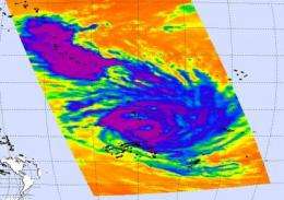
Powerful Cyclone Tomas battering Northern Fiji islands

Tomas grew into a monster Category 4 cyclone and thrashed the northern Fiji Islands with heavy rains and maximum sustained winds of up to 170 mph (275 km). The Moderate Resolution Imaging Spectroradiometer instrument on NASA's Aqua satellite captured a visible image of most of Cyclone Tomas on Mar. 14 10:21 p.m. ET and noticed the storm's eye is cloud-filled.
Another instrument on NASA's Aqua satellite measured the cloud top temperatures of Tomas' thunderstorms, and revealed very high, cold thunderstorms (as cold as minus 63 degree Fahrenheit) surrounding Tomas' 34-mile in diameter-wide-eye. The Atmospheric Infrared Sounder (AIRS) instrument showed forecasters that the thunderstorm "engine" in Tomas' center was very powerful with strong thunderstorms, dropping heavy rainfall.
Tomas has already caused damages for residents of the northern Fiji islands. Damage reports are still coming in, but power losses and flooding have been reported. Evacuations have taken place in Labassa, Wainiika, Nuku and Vatu because of flooding. Other reports indicate that schools and government buildings have been closed. Tourists were evacuated and flights have been temporarily canceled to and from Fiji's main airport.
At 0828 UTC March 15 (4:28 a.m. EDT), Cyclone Tomas was packing maximum sustained winds near 120 mph (105 knots). The center of the storm was approximately 200 nautical miles northeast of Nadi, Fiji, near 16.1 South and 179.5 West. Tomas is moving south at 7 mph (6 knots). Tomas' estimated minimum central pressure was 930 millibars.
Cyclone-force winds extend 40 miles out from the center, while tropical storm-force winds extend out 150 miles from the center, making the storm 300 miles in diameter. Tomas' eye is 30 nautical miles (34 miles) in diameter.
Infrared satellite imagery shows that Tomas has maintained its banding or wrapping around of thunderstorms around the storm's low-level center of circulation. As Tomas continues to track in a southerly direction over the next day and a half, it is forecast to intensify a little (due to the warm ocean waters it will be passing through), then will run into increasing wind shear which will weaken the storm.
Provided by NASA's Goddard Space Flight Center


