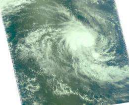
NASA's Aqua Satellite sees a tight Tropical Storm 21S

The Southern Indian Ocean is still warm enough to enable tropical cyclones to form, and Tropical Cyclone 21S did just that today. NASA's Aqua satellite captured infrared and visible images of 21S and the infrared showed some limited areas of strong convection, while the visible image showed a very small, compact storm.
At 900 UTC (5 a.m. EDT) today, March 23, Tropical Cyclone 21S was located about 505 miles west of Cocos Island near 12.9 degrees South latitude and 88.3 degrees East longitude.
Tropical Storm 21S has maximum sustained winds near 46 mph (40 knots) and tropical storm-force winds extend out to about 45 miles from the center. Today's NASA Aqua satellite visible image confirmed that 21S is a compact storm, about 90 miles in diameter.
The tropical storm was moving southwest at 8 mph (7 knots). The storm is not expected to reach cyclone strength, although it will likely strengthen a little more before encountering adverse atmospheric conditions. Tropical Storm 21S is expected to be short-lived as vertical wind shear is expected to weaken it over the next couple of days. 21S poses no threat to any land areas.
Provided by NASA's Goddard Space Flight Center


