Laurence still causing warnings and watches in northern west Australia

Although the center of Tropical Cyclone Laurence has been over land for two days, it's still holding together and bringing heavy rains and gusty winds to the northern coastal areas of West Australia and will do so into the weekend. Warnings and watches are still in effect in some areas as Laurence will continue moving west before re-entering the Southern Indian Ocean.
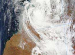
The Moderate Resolution Imaging Spectroradiometer (MODIS) instrument on NASA's Terra satellite captured an image of Cyclone Laurence over Northern West Australia on Dec. 17 at 02:00 UTC (9 p.m. ET Dec. 16) as it continued to hug the coast and track west. The MODIS image did not reveal an eye, indicating that the storm has downgraded to a tropical storm.
On December 17 at 8 p.m. local time (Perth/Australia) or 7 a.m. ET, a Cyclone Warning was in effect for areas in the Derby region of the west Kimberley. A Cyclone Watch was in effect for coastal areas from Cape Leveque to Wallal, including Broome as the storm continues to move in that direction. The area where Laurence is tracking is sparsely populated. The main industries there are energy-related and mining.
Laurence's maximum sustained winds were down to 40 mph (35 knots) making Laurence a tropical storm. Tropical Cyclone Laurence has continued to weaken as it moves slowly over land east of Derby. Wind gusts up to 59 mph (95 kilometers per hour) are possible close to the cyclone center.
Even though Laurence has weakened, he's still dumping heavy amounts of rainfall. Twenty-four hour rain totals are estimated to be as much as 11.8 inches (300 millimeters) along Laurence's track. Heavy rain is expected to continue over northwest Kimberley. Rainfall totals in excess of 4 inches (100mm) each day are expected with isolated amounts as high as 11.8 inches (300mm) possible near the path of the cyclone. Flooding is a large threat, especially for areas near the center of the storm.
At 8:00 p.m. local time (7 a.m. ET) December 17, the center of Tropical Cyclone Laurence was about 59 miles (95 kilometers) east of Derby, near 17.4 degrees South and 124.5 degrees East, and moving south at 7 mph (6 kilometers per hour). Estimated minimum central pressure is 993 millibars.
Over the next several days, Laurence will pass northeast of Fitzroy Crossing on its inland course. Then it will swing west, passing south of Derby and Beagle Bay before exiting near Broome and re-emerging over open ocean on December 19.
Laurence may re-develop into a tropical cyclone over warm ocean waters of the Southern Indian Ocean this weekend. There is low wind shear in that area, and that also enhances the chances of re-formation at sea.
Provided by NASA's Goddard Space Flight Center


