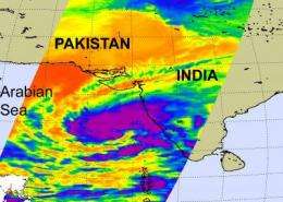
NASA sees high thunderstorms in newly formed Tropical Cyclone 4A near India

Tropical Cyclone 4A formed yesterday, November 10 off the western coast of India in the Arabian Sea, and NASA's infrared imagery captured some high, powerful thunderstorms developing in the storm's center.
Tropical Cyclone (TC) 4A formed yesterday around 4 p.m. ET, 380 miles south-southwest of Mumbai, India, with maximum sustained winds near 37 mph. By 10 a.m. ET today, November 10, 4A had moved north about 135 miles. Cyclone 4A was located about 245 miles south-southwest of Mumbai, near 15.2 North and 71.1. East. It still maintained sustained winds near 37 mph, and was moving north at 13 mph.
The U.S. Navy's Joint Typhoon Warning Center, the organization that forecasts tropical cyclones in that region of the world, noted that gusty winds between 34-40 mph (55-65 kmph) and heavy rainfall (as much as 10 inches or 250 millimeters) will affect Konkan and Goa and Madhya Maharastra over the next two days as the storm moves north. Gusty winds and heavy rainfall is also expected over coastal Karnataka, Kerala and Lakshadweep in the next day, South Gujarat will begin to feel rainfall and gusty winds from 04A on November 11.
NASA's Aqua satellite flew over Cyclone 4A on November 9 at 20:59 UTC (3:59 p.m. ET) and the Atmospheric Infrared Sounder (AIRS) instrument onboard captured an infrared image of Cyclone 4A's cold thunderstorm tops. The infrared imagery revealed that 4A's cloud tops had some strong thunderstorms around its center of circulation, where temperatures are colder than -63 Fahrenheit. That indicates strong convection and development of thunderstorms that power the cyclone. 4A is expected to continue intensifying as it moves north over the next couple of days in the Arabian Sea, paralleling the Indian coast. It is expected to make landfall east of the India / Pakistan border late Wednesday Universal Time (mid-day Eastern Time).


