NASA captures Typhoon Nida's clouds from 2 angles

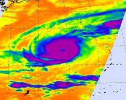
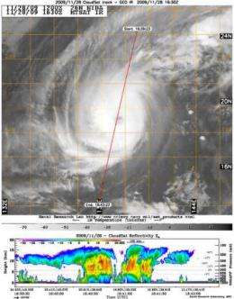
NASA satellites capture amazing views of tropical cyclones, and the Aqua and CloudSat satellites captured a top-down look at temperatures in Typhoon Nida's clouds, and an image of what they look like from the side.
On Monday, November 30, by 4 a.m. ET, Nida had lost her "Super Typhoon" status as a result of wind shear, and is now a typhoon. Nida's maximum sustained winds are near 115 mph (100 knots). The storm was over open ocean in the Western Pacific, about 330 miles south-southwest of the island of Iwo To (formerly Iwo Jima), near 19.6 North and 139.1 East. It was crawling to the west-northwest near 3 mph (2 knots), so the forecast track has become more difficult to predict.
Tropical storm force winds extend 150 miles from the center, so the storm is about 300 miles in diameter. Typhoon-force winds extend out to 55 miles from the center. Nida is kicking up 35-foot high waves in the open ocean.
NASA's CloudSat satellite's Cloud Profiling Radar captured a side look across Nida on Nov. 28. Nida's clouds are over 15 kilometers or 9 miles high. CloudSat also noticed ice in throughout all of Nida's cloud tops, indicating strong, high, thunderstorms. CloudSat also noted heavy rainfall over some of the areas where Nida meets the ocean's surface, more than 30mm/hr (1.18 inches/hour). CloudSat also provided an estimate of winds and atmospheric pressure at the time of the overpass on November 28 and clocked the wind around 140 knots and the minimum central pressure around 918 millibars.

NASA's Aqua satellite also passed over Nida on November 28 and captured infrared and microwave imagery using its Atmospheric Infrared Sounder (AIRS). The data from AIRS is also used to create an accurate 3-D map of atmospheric temperature, water vapor and clouds, all of which are helpful to forecasters. The AIRS image clearly showed Nida's eye, and strong, cold thunderstorm cloud tops, colder than -63 Fahrenheit (220 degrees Kelvin) circling the eye.
The infrared signal of the AIRS instrument does not penetrate through clouds. Where there are no clouds the AIRS instrument reads the infrared signal from the ocean and land surfaces, revealing warmer temperatures in orange and red. The orange temperatures are 80F (300 degrees Kelvin) or greater (the darker they are, the warmer they are), and tropical cyclones need sea surface temperatures of 80F to strengthen and maintain their strength.
The Joint Typhoon Warning Center is the organization responsible for forecasts of typhoons in that region, and their latest discussion noted that Nida is weakening as it continues to crawl in a northerly direction.


