A sudden Tropical Storm Grace explodes in far Eastern Atlantic

The latest tropical storm in the Atlantic Ocean may have escaped the notice of most when it formed just before midnight last night so far north and east in the Atlantic, away from where forecasters usually look for forming storms. However, NASA's Aqua satellite and forecasters in the Azores Islands, Portugal and Ireland are watching it closely.
Grace came together quickly and her winds were near 65 mph soon after formation. Very early this morning those sustained winds peaked at 70 mph, but fell back to 65 mph. Grace's existence will be short-lived as she's expected to merge with another low pressure area.
It was late last night, October 4 at around 11 p.m. EDT, when Tropical Storm Grace formed about 420 miles northeast of the Azores, near 41.2 North and 20.3 West. By 5 a.m. today, October 5, was speeding north-northeast between the Azores and the British Isles.
Grace had moved to a position about 575 miles southwest of Cork Ireland, and about 590 miles northwest of Lisbon, Portugal near 45.4 North and 16.4 West. Her maximum sustained winds were near 65 mph, and she was speeding northeast near 31 mph. Estimated minimum central pressure is 990 millibars.
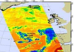
NASA's Aqua satellite AIRS instrument captured an infrared image of Grace's clouds on October 4 at 10:17 a.m. EDT more than 12 hours before she came together as a tropical storm. In the infrared imagery, which measures cloud top temperatures, there were some strong areas of convection, but the storm didn't yet have the signature appearance of a tropical storm. However, the storm quickly organized.
AIRS infrared imagery measures temperatures in the clouds, and found a few of the highest thunderstorm cloud tops were cold as -63 Fahrenheit, indicating some isolated strong convection even before the storm came together.
Grace is expected to be absorbed by a large non-tropical low pressure area over the northeastern Atlantic during the day sometime tomorrow and bring rainfall to Ireland.
Source: NASA/Goddard Space Flight Center


