More efficient solar power with space technology

(PhysOrg.com) -- A new system from an Italian company uses weather satellite data to estimate the potential of solar cell power plants and monitor their performance. The approach helps to give a faster return on investments in clean solar energy.
Solar cells have been used for many years to power pocket calculators and, more recently, street signs, garden lighting and other small devices.
But since the need for sustainable living has become a key issue in our society, there has been a considerable increase in interest in exploiting one of the environmental cleanest energy sources to generate electricity: the Sun’s rays.
It has spurred the development throughout Europe of large photovoltaic (PV) plants to generate electricity to power offices, homes and even factories.
The interest has also boosted the search for ways to improve the operation of these plants. Italian company Flyby srl has come up with ways to do just that, by using Europe’s Meteosat weather satellites to map the amount of sunshine available for such sites.
This information assists to determine the best sites for new PV plants, as well as how much electricity they will produce yearly. This helps to decide precisely how large the plants have to be for a given use, optimising investment and improving solar power economy.
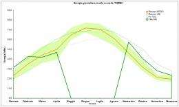
The second development uses Meteosat data to monitor if the solar cells are working properly all the time, by comparing in real-time the actual production of electricity to what can be expected from the amount of available sunshine.
The system takes data from the satellites and measurements from a ground sensor; any difference indicates the solar cells are not working optimally, and the system immediately sends an alarm. Technicians can then be called in to remedy possible faults.
The satellite solar irradiation data come from two Meteosat Second Generation satellites: Meteosat-8 and Meteosat-9. The services providing these data have been jointly developed by ESA and Eumetsat, the European Organisation for the Exploitation of Meteorological Satellites.
Making the satellite information available for commercial use is a result of the Envisolar project, funded by ESA as part of its Earth Observation Market Development Programme and led by prime contractor DLR in Germany.

ESA’s technology transfer broker D’Appolonia then helped Sonepar Immobiliare e Servizi (SIS) SpA, an Italian distributor of solar power systems, to integrate Flyby’s solution into their systems, with successful results for several plants in Italy.
“Our company is offering services and integrated solutions for energy efficiency and we are particularly focused on sources of renewable energy,” said Maurizio Testa, Marketing Director of SIS.
“It is of utmost importance for us to develop new technology for the improvement of photovoltaic technologies, our primary sector of interest.”
“The tool from Flyby has indeed allowed us to devise a system with a very high spatial resolution and capable of interacting with satellite geographical maps, like solar irradiance maps. Thus, as well as an analysis of a plant’s productivity, it is possible to obtain an economic analysis to evaluate investments [in new PV plants],” added Mr. Testa.
Good results on three solar power plants in Italy
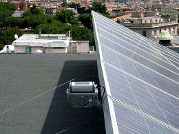
After a development phase, with the participation of the Italian energy leader Enel, the solution using Meteosat weather data is now operating on three photovoltaic plants in Italy: a 59 kW plant in Rome, a 49 kW plant in Milan and a 26 kW plant near Messina. At all sites, production has increased as malfunctions have been found and corrected.
“Photovoltaic plants do not always operate optimally because it may be difficult to spot malfunctions in the solar cells or the installation. By using the satellite information on available solar radiation as a reference, our system helps to spot anomalies faster, increasing production,” said Ciro Lanzetta of Flyby.
“In January 2009 the Milan plant experienced a failure due to snow cover. Using satellite data, this was detected very fast and corrected. Optimal operation all the time is very important. Just 10% reduction in the yearly production of a typical photovoltaic plant producing 35 000-40 000 kWh per year could extend the return on investment of the complete plant by one more year.”
Provided by European Space Agency (news : web)


