Tropical Storm Ignacio may get some company in the eastern Pacific

Tropical Storm Ignacio may not be alone in the Eastern Pacific Ocean for long. There are two areas of showers and thunderstorms that forecasters and the GOES-11 satellite are watching for development, farther east and closer to land.
NASA's infrared satellite imagery indicates that Tropical Storm Ignacio still had some punch left in him, but that won't be the case in the next day or two.
On August 26 at 5 a.m. EDT, Tropical Storm Ignacio had sustained winds near 50 mph, but he's moving into an area of adverse conditions that are expected to weaken him in the next day. Ignacio was located 815 miles west of the southern tip of Baja California, near 21.2 north and 122.5 west. He was moving northwest near 14 mph, and his minimum central pressure was 1000 millibars.

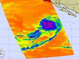
The Atmospheric Infrared Sounder (AIRS), instrument that flies aboard NASA's Aqua satellite, captured an image of Tropical Storm Ignacio yesterday that showed Ignacio still had some stronger thunderstorms around his center. That's about to change as he's entering cooler waters.
Infrared imagery is false-colored and higher cloud tops of stronger storms are depicted in purple. Ignacio showed a circular area of high, strong thunderstorms around his center of circulation on August 25 at 5:35 p.m. Those highest thunderstorms are as cold as or colder than 220 Kelvin or minus 63 degrees Fahrenheit (F).
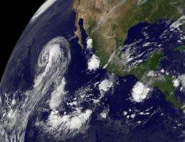
Meanwhile, the other two areas in the Eastern Pacific that are holding the interest of forecasters are closer to land and both areas were captured by NOAA's GOES-11 (Geostationary Operational Environmental) satellite earlier today.
The first area is consists of disorganized showers and thunderstorms, several hundred miles south-southwest of the southwestern coast of Mexico. The second area is a low pressure area several hundred miles south of the Guatemalan coast. Both areas have less than a 30 percent chance of developing.
The GOES-11 satellite imagery revealed that both of these clusters of showers and thunderstorms are still pretty disorganized. NASA's GOES Project at the NASA Goddard Space Flight Center in Greenbelt, Md. created the imagery using data from the satellite.
Right now, as Ignacio is forecast to fade, perhaps one or two of those other areas may take his place.
Source: NASA/Goddard Space Flight Center


