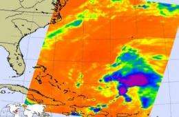
NASA sees Tropical Storm Danny form, US East Coast on watch

An area of low pressure east of the Bahamas has now powered up into Tropical Storm Danny, and NASA's Aqua satellite captured his strengthening thunderstorms in infrared imagery. Danny came together this morning, August 26, and was classified as a tropical storm at 11 a.m. EDT.
The National Hurricane Center said this morning that "interests in the Bahamas and the southeastern United States should monitor the progress of Danny."
Danny's sustained winds went from less than 35 mph to 45 mph this morning, and some slow strengthening is possible in the next couple of days. Danny's center was about 445 miles east of Nassau and about 775 miles south-southeast of Cape Hatteras, North Carolina. That's near 24.9 north and 70.3 west. Danny's minimum central pressure was near 1009 millibars. He was moving west-northwest near 18 mph and is expected to turn to the north-northwest on Friday, headed to the U.S.
Forecasters at the National Hurricane Center (NHC) used wind data from NASA's QuikScat satellite this morning to confirm Danny's tropical storm status. The NHC discussion today said, "Quikscat data and a few observations from the stepped frequency microwave radiometer show tropical storm-force winds occurring north and northeast of the center...which is the basis for the initial intensity of 40 knot winds."
Danny is a medium-sized storm, with tropical storm force winds extending 140 outward from his eye. In comparison, Tropical Storm Hilda's tropical storm force winds extend only 70 miles out from the center. Hilda is currently in the Central Pacific Ocean, moving south of the Hawaiian Islands.
The Aqua satellite also flew over Tropical Storm Danny earlier today, August 26 at 2:29 a.m. EDT and the Atmospheric Infrared Sounder (AIRS) instrument provided valuable infrared data on his cloud top temperatures. They're important because they tell forecasters how high thunderstorms are, and the higher the thunderstorm, the more powerful it is, and the data helped forecasters see there are strong thunderstorms in Danny's center of circulation.
In infrared imagery, NASA's false-colored purple clouds are as cold as or colder than 220 Kelvin or minus 63 degrees Fahrenheit (F). The blue colored clouds are about 240 Kelvin, or minus 27F. The colder the clouds are, the higher they are, and the more powerful the thunderstorms are that make up the cyclone.
The National Hurricane Center notes that "Danny is expected to cause storm total rainfall of 2 to 3 inches with maximum amounts of 4 inches over the central and northwestern Bahamas. Total rainfall of 1 to 2 inches is expected over the southeastern Bahamas and the Turks and Caicos Islands."
Source: NASA/Goddard Space Flight Center


