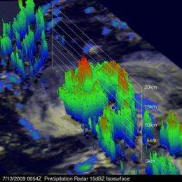
NASA sees Carlos power back up to hurricane status in 3-D

Carlos became a hurricane for about 24 hours over the previous weekend, then powered down to a tropical storm and now atmospheric conditions have enabled him to power back into a hurricane in the Eastern Pacific Ocean.
NASA's Tropical Rainfall Measuring Mission (TRMM) satellite has been capturing images of Carlos since it was born as tropical depression #4E last week. Scientists at NASA can use TRMM data to provide forecasters a 3-D look at the storm's cloud heights and rainfall, which is extremely helpful in forecasting.
"One of the interesting capabilities of the TRMM satellite is its ability to see through clouds with its Precipitation Radar (PR) and reveal the 3-D structure within storms such as Hurricane Carlos," said Hal Pierce, on the TRMM mission team in the Mesoscale Atmospheric Processes Branch at NASA's Goddard Space Flight Center, Greenbelt, Md.
Pierce created a 3-D image of Carlos. He used data captured on July 13 when TRMM also got a "top down" view of the storm's rainfall, and created a 3-D image that shows thunderstorm tops reaching to almost 15 kilometers (9.3 miles) high in the eastern side of the storm.
On Tuesday, July 14, 2009 at 6 a.m. EDT (3 a.m. PDT), Carlos had regained hurricane status as a Category One storm on the Saffir-Simpson Scale with maximum sustained winds near 75 mph. Carlos was located near latitude 9.7 north and longitude 127.2 west. That's about 1,465 miles or southwest of the southern tip of Baja California. Carlos continues to move west near 9 mph and has a minimum central pressure of 987 millibars.
Carlos is predicted to move to within about 720 miles southeast of the Hawaiian Islands on Saturday, July 18, 2009.
More information: For daily NASA hurricane and satellite image storm updates, go to the NASA Hurricane/Tropical Cyclone page at hurricane" target="_blank">www.nasa.gov/hurricane .
Source: NASA/Goddard Space Flight Center


