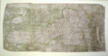
The Gough Map: the earliest road map of Britain?

One of the most important and earliest maps ever made in Britain is the subject of a new book just published by the Bodleian Library.
The Gough Map: The earliest road map of Britain explores the hidden secrets and baffling detail of one of the greatest medieval cartographic artefacts. Dating from around 1360, the Gough Map is the earliest surviving map of Great Britain to show routes across Britain and to depict the island with a recognizable coastline. Although the identity of the map-maker is unknown, the map can be accurately dated by historical reference and the handwriting on the map.
The anonymous artefact – which takes its name from Richard Gough, an 18th-century antiquary and authority on British topography – has been under continuous analytical scrutiny, for centuries.
Recent digitization of the map is helping to provide answers to some of these questions and is making the map more legible than at any other time since its arrival in the Bodleian in 1809. This process has also made it possible to project a modern map of Britain over the Gough Map (georectification), demonstrating the remarkable accuracy of much of this 650-year-old route map.
Here in stunning detail are the principal medieval settlements of Great Britain, from Bristol, through Oxford, and over to Norwich; the Severn, Thames, and Humber rivers, and even the loop of the Wear at Durham; Scotland, assuming an unfamiliar shape; the routes between towns, marked in red with distances included in Roman numerals; and even a single tree, identifying the New Forest.
This beautifully illustrated book contains not only a fold-out print of the map but also many close-up images of each area, providing an unparalleled opportunity to view this spectacular and engaging survival from medieval map-making.
Nick Millea, Map Librarian, Bodleian Library, said: ‘The Gough Map is one of the Bodleian Library’s greatest treasures. There is no record of any similar contemporary map at such scale or indeed accuracy: such is its quality and detail that it remained the blueprint for cartographers for 200 years.’
Source: Oxford University


